The Impact of Drones on Real Estate Photography in 2025
- Geoff Green

- Sep 23, 2025
- 3 min read
In 2025, drones have become a transformative tool in real estate photography, offering unprecedented aerial perspectives, data-driven insights, and immersive virtual tours. The technology has shifted from being a niche luxury service to an essential part of modern property marketing.

This article explores the current state of real estate drone photography, the market impact, technological innovations, regulations, financial considerations, and the future outlook.
The Evolution of Real Estate Drone Photography
Before drones, real estate photography was limited to static ground-level images. While traditional photos showcased interiors and facades, they often failed to capture the property’s full scale, lot layout, and surrounding neighborhood. Buyers lacked a holistic understanding of properties, particularly larger estates or commercial sites.
Drones, equipped with high-resolution cameras and AI-assisted flight capabilities, now allow real estate professionals to create comprehensive visual narratives. By 2025, these tools are used not just for marketing, but also for inspections, mapping, and immersive tours.
Key Technological Advancements in 2025
Extended Flight Times: Modern drones can fly 45–60 minutes per battery, covering large properties efficiently.
8K and 360-Degree Cameras: Drones such as the Antigravity A1 capture ultra-high-definition 360° footage for immersive virtual tours.
AI-Assisted Flight Paths: Artificial intelligence optimizes flight routes, automatically adjusting for lighting, angles, and obstacles.
LiDAR and Photogrammetry: Advanced sensors enable accurate 3D mapping of properties, useful for both marketing and professional architectural or surveying purposes.
FPV (First-Person View) Fly-Throughs: Cinematic fly-throughs enhance engagement, offering a more dynamic perspective than traditional overhead shots.
Market Trends and Economic Impact in 2025
The real estate drone services market is projected to grow from $0.49 billion in 2024 to $0.57 billion in 2025, reflecting a CAGR of 16.0%. Adoption is highest in luxury residential and commercial real estate markets, where visual storytelling is critical.
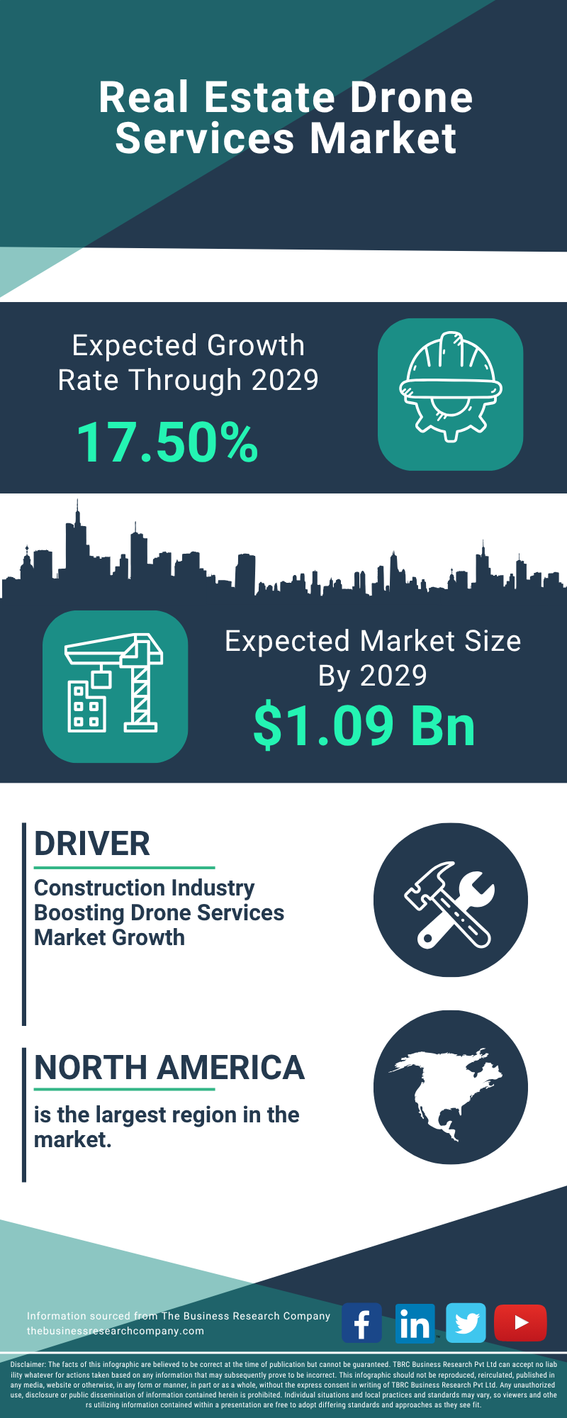
Cost and ROI of Drone Services
Residential Packages: Drone photography packages typically start at $249 for 10–15 aerial photos. Combined photo and video services range from $249–$499 (HomeJab 2025 Pricing).
Luxury and Commercial Properties: High-end packages, including 3D mapping and FPV videos, can exceed $1,000 per project.
Return on Investment: Zillow reports that listings with aerial imagery and 3D tours sell faster and at higher prices than standard listings (Zillow 3D Home).
Regulatory Landscape in 2025
FAA Part 107 Certification
In the United States, operating drones commercially requires a Remote Pilot Certificate under FAA Part 107. Certification ensures operators understand airspace regulations, privacy laws, and safe operation practices. Compliance is particularly crucial in urban areas and near airports.
Best Practices for Drone Photography in Real Estate

Pre-Shoot Planning
Property Scouting: Identify key features such as gardens, pools, driveways, and views.
Optimal Timing: Schedule shoots during golden hours for the best lighting.
Weather Considerations: Avoid rain, fog, or high winds.
Equipment Recommendations
Drones with 4K–8K cameras and gimbal stabilization
High-quality batteries for extended flights
FPV drones for cinematic videos
LiDAR or photogrammetry sensors for 3D mapping
Shooting Techniques
Combine aerial shots with traditional interior photos for a complete visual story.
Capture overlapping images for 3D reconstruction and floor plans.
Use AI-assisted modes for consistent framing and exposure.
Post-Processing Tips
Maintain realism while enhancing colors and contrast
Highlight unique property features
Create virtual tours combining aerial and interior footage
Advanced Applications Beyond Marketing

Construction Progress Monitoring: Drones capture time-lapse and site overviews for developers.
Roof and Infrastructure Inspections: High-resolution imagery identifies structural issues.
3D Mapping for Architects: Platforms like Autodesk Reality Capture allow precise 3D models and point clouds.
Case Studies: Real Estate Drone Photography in 2025
Luxury Residential Properties
Drones are now standard in luxury listings. Aerial and FPV fly-throughs significantly improve buyer engagement, emphasizing property scale and amenities.
Commercial Real Estate
Drones showcase office parks, retail centers, and industrial sites from unique perspectives, helping investors and tenants evaluate locations efficiently. 3D maps and thermal imaging add another layer of analysis for commercial decision-making.
Future Outlook: The Next Frontier
By the end of 2025 and beyond:
AI Integration: Drones will fully automate flight paths, composition, and lighting corrections.
VR/AR Immersion: Buyers will experience fully interactive property tours remotely.
Data Analytics: Drone footage will integrate with property management platforms for predictive insights.
Conclusion
In 2025, drones are no longer optional in real estate photography - they are essential tools that enhance property listings, improve engagement, and streamline marketing workflows. Professionals who adopt AI-assisted drones, immersive VR tours, and compliance best practices will have a significant competitive advantage in the rapidly evolving market.


Comments